By Pat Neal
This week has been like living in a smokehouse with swirling masses of smoke blowing in from every direction. We are reminded of the value of what we take for granted, clean air. People wonder if things have ever been this bad. A short look back into history will tell us things have been this bad and a lot worse.
All you have to do is look at a map and notice names like Burnt Hill, Burnt Mountain, Mt. Baldy and Baldy Ridge or look at some of the old photographs of the mountains above Sequim and Port Angeles with the bare hills in the background to know that almost all of the Olympic Peninsula has been burned at one time or another.
Native Americans’ traditions confirm this theory with legends of fires sweeping across the entire peninsula. These fires may be connected to the Medieval Warm Period between 900 and 1300 AD when global temperatures were warmer than the present.
The arrival of the Europeans caused still more fires. In 1868 smoke from forest fires was so thick that sailing ships in the Strait of Juan de Fuca and Puget Sound had to navigate by compass. One captain gave up and anchored in the smoke reporting that dead birds fell by the hundreds around the ship.
The early homesteaders looked upon the forests as weeds that got in the way of agriculture. They used fires to clear their stump ranches and fires got away.
The book, “Dungeness, the Lure of the River,” describes a Happy Valley feud in the 1870s where one neighbor tried to burn out another by starting a forest fire. The wind shifted and the fire burned south. That’s how Burnt Hill got its name. The fire traveled west across Blue Mountain to Mount Angeles.
September 12, 1902, saw the smokiest day on record when homesteaders on the Queets and Hoh Rivers noticed that the sky got so dark the chickens went back to the roost shortly after sunrise. This was caused by a cloud of smoke and ash coming from the Yacolt burn on the Lewis River in Clark county. The smoke from the Yacolt Burn was so thick in Seattle the streetlights came on at noon. One theory claimed the fire was started by some boys trying to burn up a hornet’s nest down in Oregon. The fire jumped the Columbia River traveling 30 miles in 36 hours, 38 people died in the fire.
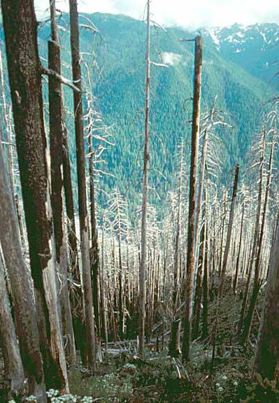
In 1907 a rotten log that had been smoldering just west of Lake Crescent burst into flames with a strong east wind burning 12,000 acres. The burn was replanted by 1910 only to be burned again in 1926 when a passing motorist tossed a cigarette out the window and started another fire.
That’s nothing compared to the Forks Fire of September 1951 when another east wind fanned another smoldering log into another fire that burned 30,000 acres and almost incinerated Forks.
After the fire, roads were built through the Forks burn for timber salvage and fire protection. Unfortunately, instead of maintaining our forest access roads for fire protection and recreation, many have been removed as an excuse for salmon restoration. Building the forest roads caused erosion but taking them out causes still more erosion. Erosion from roads is bad but erosion and collateral damage from forest fires is worse.
When and not if we have another fire, these roads would have been a valuable asset to firefighters. With forest access roads eliminated, we have one less tool to fight forest fires. Which could prove things can always be worse.