Starting the search for local evidence of the tsunami that hit the West Coast in 1700, a caravan of mixed group teachers, including K-12, park/museum (information education) and emergency management educators, bumped along the muddy road to the Waatch River Prairie Estuary, Saturday, Oct 11.
They arrived as part of the Cascadia Earthscope Earthquake and Tsunami Education Program (CEETEP), Oct. 10-13, funded by the National Science Foundation. They stayed at the Olympic Natural Resource Center just south of Forks.
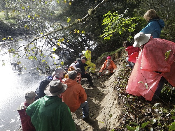
The whirlwind field trip began at the Neah Bay Community Center at 9:15 a.m., car-pooling to the Waatch Prairie Estuary for some hands-on examination of a tsunami layer.
Despite the first thunderstorms of the Pineapple Express, two succeeding groups climbed carefully down muddy riverbanks to examine evidence of a thousand-year-old tsunami. They watched Dr. Brian Atwater point out the narrow layer of chunky muck and reddish oxidation within the grey sandy soil.
Atwood is one of the pioneer geologists who spearheaded the collection of evidence proving the Cascadia coast took high-powered earthquakes and tsunamis.
The carefully excavated riverbank cut was approved and supervised by Makah Tribal representatives. Two of these accompanying the tour included Polly McCarty and Andrew Winck.
The groups then exchanged places to listen to Dr. David Yamaguchi, whose specialty is “dendrochronology” or the use of tree rings to pinpoint dates. Yamaguchi is a researcher previously affiliated with University of Washington and USGS (US Geological Survey). He described how some of the last of the truly old-growth trees remaining on the coast led to the discovery of written records verifying the 1700 date.
The only earthquake big enough — at 9 on the Richter scale — to have generated a tsunami powerful enough to hit both the West Coast and Japan in 1700 was found to have been recorded in contemporary Japanese records. According to the old records, that event would have occurred on the West Coast in January, at 9 p.m., over 300 years ago.
Pacific Northwest coastal tribal legends and oral histories speak of a great wave that long ago came ashore and wiped out villages, during the winter, at night. Tribal peoples kept insisting on the truth of these stories and finally science matched the details.
Yamaguchi said, “They told us so!”
The tour then continued on to a tour of the Neah Bay tsunami emergency escape route, trooping on to the Makah Cultural and Research Center, before ending up at the GPS Station at the Quillayute State Airport.
The high speed of the tectonic plate movement is reflected in the movement of the GPS station. Anchored in solid rock, the station has drifted with that rock three inches north and five inches east in a short nine years. That might not seem a lot in human walking terms, but when it comes to the movements of massive continental plates, you can practically feel the breeze.
CEETEP coordinator Beth Prat-Sitaula said, “The overall purpose of the program is to make sure that as many of the educators in coastal Washington and Oregon know the science and preparedness of earthquakes and tsunamis well enough to teach it well.”
While evidence of the 1700 tsunami has been pinpointed all along the West Coast, from north of Vancouver, Canada, to southern California, research on its effects and evidence on the Waatch only have begun.
The oral history states that the same tsunami hit the village of Deah (modern Neah Bay) from behind, rather than from the front. Nothing would stop a tsunami flow from channeling over the prairie to reach the settlement from the rear. Verification of the actual flow route will come with future studies.
Such an opportunity for freshly mapping unknown geophysical history is exciting and offers a future of science study, degrees and funding for interested students — and right here, on the Olympic Peninsula, where students could contribute to important details where they grew up.
Because tectonic plates make land surfaces sink and rise, there’s no telling where the evidence of the 1700 tsunami might be. Geologists will search everywhere, because such evidence could be anywhere, even — to stretch the point — at the top of the high hills that line the prairie.
Four Forks teachers accompanied the study; Megan Rains, John Hunter, Carl Rohrer and Stephanie Miller. They all teach science in the Forks school system.
According to the teachers, students often ask questions about science as though expecting complete and permanent answers. Science is constantly becoming more and more complicated, because every answer verified simply opens up hundreds more.
About 5,000 years ago, what could be called early science said the sun went around the Earth, because observers only had the human eye as a tool. With the advent of mathematics and more and more sophisticated measuring devices and telescopes, the reality of the Earth’s orbit within the planetary system was secured.
Officials don’t yet know anything specific about the 1700 tsunami on the Waatch, but the studies will continue and the story will slowly come into view.